Using Google Earth to plan your Murray River kayak trip
Kym’s recently been doing a number of “study tours” of the creeks and backwaters in our area, covering almost 300km by kayak. (It’s a tough job, but somebody’s got to do it!) So he has a great knowledge of where to paddle, camp and access our wonderful wetland system – which is in prime shape! The water is currently at a good level – many backwaters still accessible, some gorgeous wetlands to explore, and as an added bonus of the high water – some creeks which were previously inaccessible due to clogging with reeds, have been cleared out.
The Murray River, like any river system, is a living thing – constantly changing: Erosion on the corners of river bends eventually cut through and cause oxbow lakes, man-made regulators are placed, creeks can get overgrown with reeds, and of course, river levels change – sometimes creeks are full and sometimes they’re not.
One of the tools Kym uses, and that you can use to plan your Murray River kayak trip, is Google Earth, (which can be downloaded for free from here) . In our area – Riverland SA, through to the Murray Sunset National Park - Google has recently updated their imagery. “That’s great,” I hear you think, “up-to-date visuals of the creeks and backwaters”. Only one problem here – in some areas they are updated to 2012 – that’s when we had a lovely high river, so it looks like there is an limitless maze of little creeks and nooks and crannies to explore. So don’t be tricked into planning your trip based on where the water appears to be in the images. Read on to find out more.
Google Earth's History Function
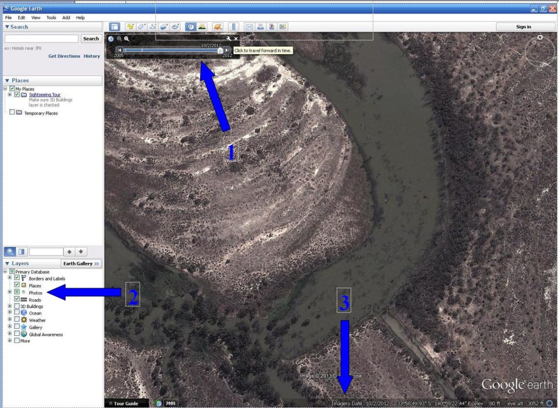
There is a partial solution – Google Earth has a history function which can show you previous satellite imagery. The arrow below, shows where to click to show the historical imagery.
Once you’ve clicked there, the arrow at (1) below shows the history slider that you move to get images from different times. The slider will tell you the date of the image it is showing. Arrow 3 shows another place to look for the date of the image. You might find it useful to compare the images to recorded river level data. Click here to open a spreadsheet file with recorded river levels from Jan 2003 - July 2013, from Lock 2 to Lock 6. This data is supplied by the Murray Darling Basin Authority, with the following annotation - "The information enclosed is provided 'without prejudice' to the interests of the Murray-Darling Basin Authority. It is provided on the basis that the user of the data acknowledges that the Murray-Darling Basin Authority has no responsibility in terms of the accuracy, interpretation or use of the data."
Arrow 2, on the left of the picture above, shows where to check the box, to include icons on the map, which show where people have uploaded images of the landscape. When looking at maps on Google earth, looking at these images can give you an idea of whether you want to paddle in that area.
Calculating distance
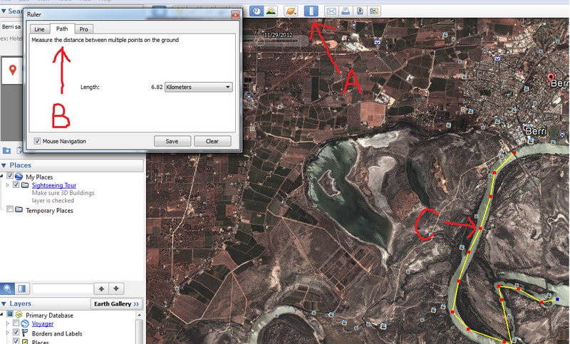
Another useful tool is the ruler tool - located almost directly above the number 1, on the picture above.at "A" in the picture above. Once clicked on, it opens up box "B" underneath . Click on the "path" tab in box B. This will allow you to click along the route, causing the distance of the route to appear in the middle of the box. It allows you to select which units of measurement you'd like that distance in. (I must find out what distance a "smoot" is!) 4km/hr is a very comfortable paddling speed, so if your trip is 8km, give yourself 2 hours - this will allow a time to paddle, take photos, and have a few mouthfuls from your water-bottle, without feeling too rushed.
But - nothing beats the help of real people.
And just a reminder – other tools are necessary too – like a good map, and speaking to someone who has had prior experience in the area, like Kym. As an example – fallen trees which can block the creek, sometimes just under the water, don’t generally show up on satellite imagery, and certainly don’t show up on maps. And there are a few spots where the effort of hauling your kayak over numerous logs just isn't worth it.
Wishing you lots of happy paddling. What tools do you find useful to help you plan your trip?